


Our ability to harness the power of the wind plays a pivotal role in the transition to a greener and more sustainable future. Staring down the pressing challenges of our changing climate, environmental degradation, and the transition away from our reliance on depleted fossil fuels, wind power represents one of the most scalable and cost-effective renewable energy sources.
The development of new wind farms promises to deliver clean electricity to millions while creating jobs and boosting local economies. However, realizing the full potential of wind energy hinges on accurately assessing wind resources during development.
As we strive to optimize the efficiency, reliability, and cost-effectiveness of wind-resource assessment, the debate between Lidar technology and traditional meteorological masts for wind measurement grows increasingly lopsided. While met masts have helped companies collect on-site wind data for decades, many developers now consider Lidar a viable alternative to met masts for wind resource assessment and other applications due to the technology’s proven repeatability and enhanced accuracy over recent years.
With the wind industry actively evaluating the strengths and limitations of both approaches, projects such as the Corlacky Hill Wind Farm help provide real-world evidence of Lidar’s capabilities in delivering finance-grade wind measurements safely and cost-effectively.
 The Essential Role of Wind-Resource Assessment
A crucial, early-stage process in developing any wind farm, wind resource assessment (WRA) provides the critical data about wind behavior needed to determine project feasibility, select appropriate equipment, situate turbines, and estimate energy production.
Every wind farm is unique and presents distinct challenges, so the importance of WRA — underpinning virtually every aspect of wind-energy development — cannot be overstated.
Without accurate data on wind speeds, direction, and other weather parameters, determining whether a wind-energy project is even financially and technically viable is impossible. Accurate WRA data is critical to securing project financing since lenders and investors rely on the accuracy of these models to assess a project’s financial viability. But WRA is also essential for meeting power purchase agreements and regulatory requirements.
High-quality WRA data minimizes uncertainty around energy-production estimates, allowing developers and regulators to trust performance projections decades into the future after turbine commissioning.
Given the substantial capital costs of wind-energy projects, the methods and technologies used to measure these wind resources massively affect project outcomes. Consequently, the Lidar vs. met mast debate is increasingly relevant as wind farms expand in scale and scope.
Met Masts vs. Lidar for Wind Resource Assessment and Characterization
Towering structures equipped with anemometers and other meteorological instruments, met masts have traditionally played a crucial role in providing the industry with valuable insights and accurate point data.
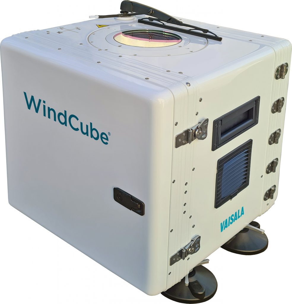
However, as Lidar technology matures, it emerges as a compelling alternative to traditional met masts for wind resource assessment and permanent wind monitoring. Lidar — light detection and ranging — uses laser pulses to sense wind conditions remotely, providing expanded coverage and flexibility compared to fixed met towers. While some decision makers have only begun discovering the full potential of Lidar technology, others are fully integrating Lidar campaigns into their regular measurement practices.
Between turbines growing taller and wind farms expanding across diverse terrains and into offshore environments, met mast limitations are evident: the need for data extrapolation, long permitting processes, high equipment and maintenance costs, and significant safety hazards. And these increasingly apparent challenges are prompting players across the wind-energy industry to explore alternative technologies for wind measurement, setting the stage for Lidar technology to prove itself as an attractive alternative.
Corlacky Hill Wind Farm Case Study
One such organization is the RES Group, a global player in the renewable energy sector for more than 30 years.
Delivering more than 23 GW of renewable energy projects and supporting a large client base across 14 countries, RES has deployed about 2,000 wind-measurement systems, including 1,700 met masts. During this time, 2 percent of those met masts collapsed, presenting severe safety concerns. Striving to make WRA campaigns safer, cheaper, faster, and bankable, RES replaced met masts with accurate and reliable remote sensing Lidar technology as a standalone instrument for wind measurement at the Corlacky Hill Wind Farm site in Northern Ireland.
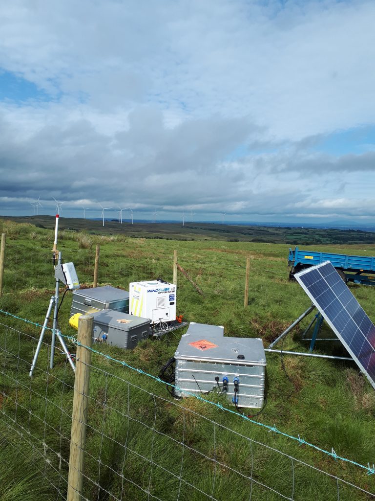
RES used a Vaisala WindCube vertical profiling wind Lidar to conduct a 12-month measurement study at the 11-turbine, 47-MW wind farm, owned by ERG, set in gently sloping, relatively benign terrain with minimal forestry.
The wind Lidar’s overall measurement uncertainty at hub height was 2.4 percent, based on the International Electrochemical Commission recommendations for assessing uncertainty and weighted by site-specific wind-frequency distribution. Obtaining a p90/p50 value of about 90 percent, the project achieved market standard uncertainty levels and exceeded the expected market threshold.
In light of the Corlacky Hill project, RES sees several distinct advantages of Lidar over met masts.
Met Mast Limitations and the Advantages of Lidar
Met masts only measure wind at fixed points where sensors are installed on each tower. With today’s average turbine hub heights surpassing 100 meters, these free-standing towers often cannot directly measure wind parameters at desired heights. Instead, data must be extrapolated from lower heights, adding uncertainty to the assessment.
Additionally, as wind plants expand across larger areas and into increasingly challenging terrain, multiple met towers are needed to capture spatial differences in wind flows across a site. Indeed, data from only one location may not comprehensively understand the site’s potential, leading to suboptimal turbine placement and minimized energy generation. On the contrary, Lidar measures wind conditions at adjustable heights from 40 to 300-plus meters, enabling direct measurement at existing or planned turbine hub heights, and it can be relocated easily from one location to another, offering the flexibility to assess various areas of a wind farm and better coverage across the entire project site.
By directly measuring at hub height rather than extrapolating up from lower met masts, Lidar minimizes bias and uncertainty around wind-speed estimates, as evidenced at Corlacky Hill, where the Lidar achieved 2.4 percent uncertainty.
The installation, permitting, and equipment costs associated with tall met masts are also substantial. Industry leaders estimate that just buying and installing a 100-meter met mast costs up to $130,000, with no manufacturing, transportation, construction, or permitting fees included. When some measurement campaigns run for one to three years, these costs and delays quickly add up. In contrast, Lidar units can typically be installed and begin collecting data in less than a day. Rapid deployment significantly reduces project lead times and accelerates the transition from site assessment to energy generation. Additionally, Lidar is becoming more cost-effective and proves to be a reliable measurement device, eliminating the need for traditional met masts.
Making matters worse, the height of most met masts makes them a safety hazard. Not only do maintenance or inspection personnel have to climb them, putting people at risk of falls, but the structures are also susceptible to icing and snow damage, collapse, or lightning strikes. Collapses endanger the environment and surrounding areas, leading to costly replacements and potential project delays. With no exposed towers, Lidar eliminates safety hazards associated with the construction, maintenance, and operation of met masts.
Finally, Lidar helps lower costs, with the RES Group realizing a 37-percent cost savings by using Lidar instead of additional met towers for the Corlacky Hill project.
“Our current standalone remote sensing measurement strategy is borne out of the work undertaken at Corlacky Hill and another wind farm in northern Scotland,” said Iain Campbell, senior technical analyst and wind resource manager at RES. “Not only does this strategy result in safer, bankable measurement campaigns, a 12-month standalone Lidar measurement campaign is also faster and cheaper than a traditional met mast measurement campaign.”
Lidar Moving the Wind Industry Forward
Wind energy’s growing scale and competitiveness drive rapid innovation in resource assessment technologies — and Lidar is leading the way. The demand for accurate measurements in the face of ongoing industry evolution and expansion reveals how pronounced the limitations of meteorological masts are.
Industry leaders such as RES are at the forefront of validating Lidar’s capabilities through real-world case studies like Corlacky Hill that highlight Lidar’s advantages for preconstruction WRA, including:
- Fast and safe setup in less than a day.
- Precise hub height wind measurements across a broad area.
- Bankable data accuracy under 2.5 percent uncertainty.
- 37 percent cost savings compared to met towers.
Corlacky Hill demonstrated that today’s advanced Lidar systems can deliver finance-grade wind resource assessments more flexibly and cost-effectively than met masts alone.
The wind industry is clearly embracing Lidar’s expanding capabilities, signaling the remote sensing technology’s growing status as the new gold standard for wind measurement.


